 Art & Design
 Auto & Vehicles
 Beauty
 Books & Reference
 Business
 Comics
 Communication
 Dating
 Education
 Entertainment
 Events
 Finance
 Food & Drink
 Health & Fitness
 House & Home
 Libraries & Demo
 Lifestyle
 Maps & Navigation
 Medical
 Music & Audio
 News & Magazines
 Parenting
 Personalization
 Photography
 Productivity
 Shopping
 Social
 Sports
 Tools
Tools
 Travel & Local
 Video Players & Editors
 Weather
 Action
 Adventure
 Arcade
 Board
Board
 Card
Card
 Casino
 Casual
 Educational
 Music
Music
 Puzzle
 Racing
 Role Playing
 Simulation
 Sports
 Strategy
 Trivia
 Word
Word


About Norgeskart Outdoors
🤞Norgeskart Outdoors (Package Name: no.avinet.norgeskart) is developed by Ture Apps AS and the latest version of 3.22.4 was updated on 2023-12-09. Norgeskart Outdoors is in the category of Maps & Navigation. You can check all apps from the developer of Norgeskart Outdoors on Android. Currently this app is for free. 🌹 This app can be downloaded on Android Android 5.1+ on ApkDowner or Google Play. All APK/XAPK files on APKDowner.com are original and 100% safe with fast download 😋
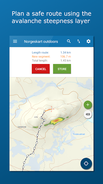
Norgeskart Outdoors has all what you need for hiking, biking, boating or skiing. Everything can be made available for offline use without mobile coverage. Includes topographically maps for Norway, Svalbard, Jan Mayen and Sweden. Now also with altitude (including depth at sea) and place name for any given location in Norway!
Record GPS tracks, register points of interest (POIs) and routes. Registered data can, if desired, be written to GPX files or uploaded to the map portal norgeskart.avinet.no. You can then look at your own data in the browser and easily transfer between phones and tablets. In the app you can also read content from GPX files that you find on ut.no or other sources.
Plan your next trip by downloading trip suggestions and descriptions from TellTur and GodTur. Everything available regardless of mobile coverage. For Telltur you can register with the app when you arrive at a destination and compete with others to visit most places. You can easily find current trips by filtering and sorting the list of hiking destinations from your location or center of the screen.
This app contains both free and paid content (see complete overview below). By paying for a subscription, you support the further development of the app and take full advantage of all the exciting things we have to offer.
Free content:
------------------
- Topographical and nautical maps for Norway, Svalbard and Jan Mayen
- Trip suggestions and check in for telltur.no (free in 2022)
- Trip suggestions from godtur.no (website is to be shut down soon)
- Map layer with anchorages for Norway
- Altitude and place name for crosshair location in Norway.
- Search for addresses, place names and coordinates.
- Property borders and UTM grid layers
- Record GPS tracks
- Import and export of GPX files
- Display imported tracks as graphs.
- Create own routes and POIs
- Compass
- Driving directions
Premium subscription:
------------------
- Topographically maps of Sweden.
- Download maps for offline use (Sweden limited to storage by panning and zooming)
- Access to map portal norgeskart.avinet.no
- Upload POIs, tracks and routes
- Synchronize your data across devices
- Advanced properties layer (cadastre)
- Outports. Not nationwide.
- Sea depts
- Lake depths
- Activities (bath spots, campfires etc). Not nationwide.
- Facilities (toilets, parkings etc). Not nationwide.
- Mountain bike routes for Scandinavia
- Pistes Alpine and Cross-country for Scandinavia
- Avalanche awareness and steepness
- Weak ice
- Snow depth and skiing conditions
- Snowmobile tracks for Scandinavia
- Conservation areas
- Traffic restrictions (nature)
- Clay and radon
Dynamic point subscription:
------------------
- Connect to one or more dynamically updated KML files on the internet
- Tested against telespor.no for tracking sheeps
Norgeskart Outdoors Update
3.22.3:
- Fixed log in on Android 5.x devices
- Some improvements when adding own maps
3.22.x:
- New Pro+. Add own maps and layers (WMS, WMTS, XYZ, TMS) for UTM33 or Mercator.
- Added support for west and south coordinates.
Install Norgeskart Outdoors APK on Android
1.Download Norgeskart Outdoors APK For ApkDowner.
2.Tap Norgeskart Outdoors.apk.
3.Tap Install.
4.Follow the steps on screen.

 716M+
716M+


 5M+
5M+
 2022-07-24


